

- Hurricane Ian is expected to make landfall in Florida soon. The eyewall of the hurricane is already moving over the coast.
- Hurricane Ian remains a high-end Category 4 cyclone with sustained winds of 155 mph (249 km/h) and higher gusts, which will make it the strongest cyclone to ever make landfall on the western coast of the Florida panhandle. .
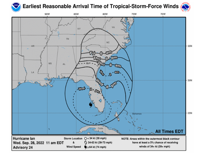
- The cyclone is starting to slow down, and is now moving forward at about 9 mph (14 km/h), according to the latest update.
- The slow movement will allow the worst conditions to remain in some places for eight hours or more.
According to the National Hurricane Center (NHC), the hurricane would make landfall in Florida around 2 pm ET. Ian’s track remains uncertain, but the NHC forecasts that by Wednesday night (8 pm ET) Ian will be further up the East Coast, having passed through the state.
The hurricane is expected to continue west through Thursday morning, according to the most recent update.
- An extreme wind warning is in effect for Cape Coral, Bonita Springs and Estero until 12:45 p.m. ET, according to the National Weather Service in Tampa Bay.
- “Treat these impending extreme winds like an approaching tornado and immediately move to an interior room or shelter RIGHT NOW!” the weather service said.
- Tampa International Airport has extended its closure due to the hurricane.
- Ian’s expected intensity as it crosses Florida has increased and is now forecast to maintain more of its overall strength as it moves through the state.
- This will expose more people in the central and eastern parts of the state to damaging hurricane-force winds.
- “A major change is that Ian is likely to remain more intact as it crosses the Florida panhandle (due to both the stronger initial wind speed and faster forecast forward speed), and this now increases the threat of hurricane-force winds off the east coast of Florida,” he said.
- With that in mind, the NHC has also added hurricane warnings to Florida’s east coast. In addition, it also updated various watches and warnings for Florida to South Carolina.
This includes:
- A storm surge warning from the mouth of the St. Mary’s River to the mouth of the South Santee River, South Carolina.
- A hurricane warning from Sebastian Inlet, Florida, north to Flagler/Volusia County Line, Florida.
- A Hurricane Watch from the Flagler/Volusia County line to the South Santee River.
- A tropical storm warning has been extended as far north as Little River Inlet, South Carolina.
What we know about Ian’s storm surge in Florida
- The storm surge in Southwest Florida is likely unlike anything the region has ever seen.
- Hurricane Charley, also a Category 4, hit the same area in 2004, bringing a maximum of 6 to 7 feet of storm surge (1.8 to 2.1 meters). This could be at least twice as high.
- The storm surge is expected to be higher than Hurricane Michael, a Category 5 storm that brought a storm surge of 9 to 14 feet to the Panhandle in 2018 (2.7 to 4.21 meters).
- Editor’s Note: This article was originally published on September 26 and has been updated with the latest information.


0 Comments